Moeraki Boulders – New Zealand
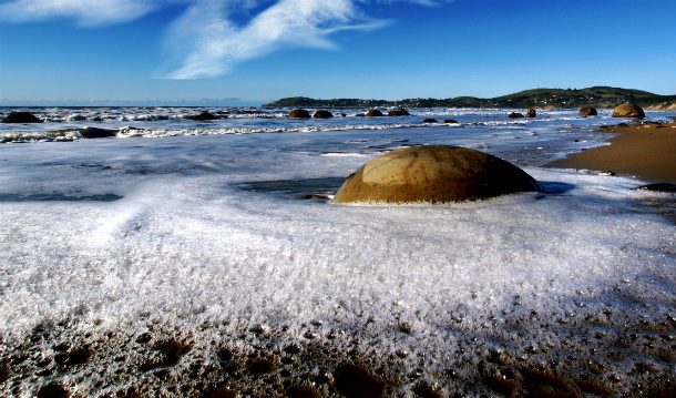
These unusually large and spherical boulders lie along a stretch of Koekohe Beach on the coast of New Zealand. Their origin has been the subject of numerous Maori legends, but scientifically speaking, they are the result of coastal erosion.
White Desert – Egypt
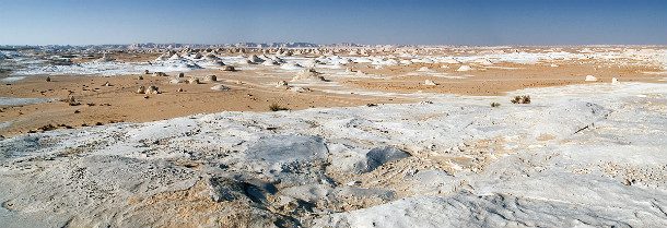
Known as Sahara el Beyda, with “sahara” meaning desert, this barren stretch of unique land is located 45 km outside the town of Farafra. It is famous for its white cream color and its massive chalk rock formations that are the result of occasional sandstorms in the area.
The Giant’s Causeway – Northern Ireland
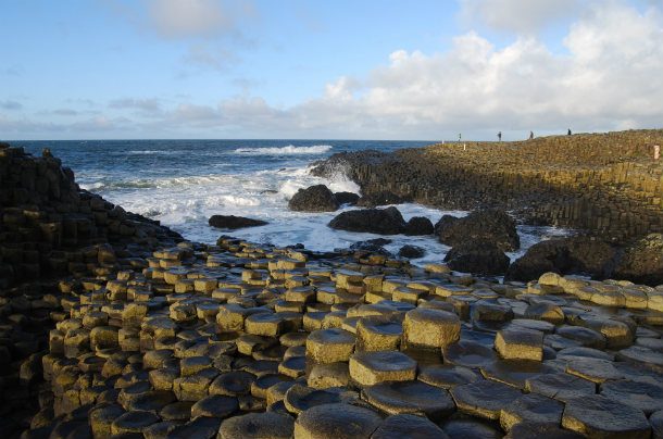
The Giant’s Causeway is an area of about 40,000 interlocking basalt columns, the result of an ancient volcanic eruption. The tops of the columns form stepping stones that lead from the cliff foot and disappear under the sea. It was declared a World Heritage Site by UNESCO in 1986.
Reed Flute Cave – Guangxi Province, China
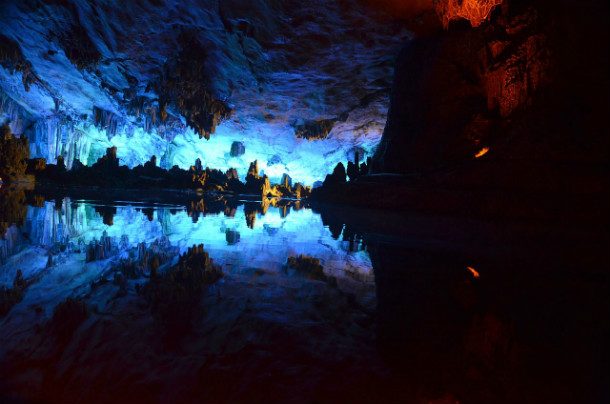
The Reed Flute Cave looks like something out of a science fiction movie. Its multicolored lighting has been an attraction for the past 1,200 years. The cave got its name from the type of reed growing outside, which can be made into melodious flutes.
Mono Lake – California
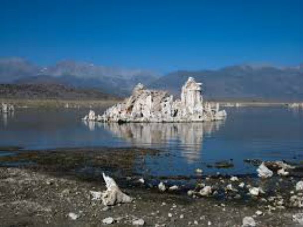
Mono Lake is a large, shallow lake with no outlet to the ocean. The lack of an outlet causes high levels of salt to accumulate. Although its high alkalinity is not livable for fish, it still has an unusually productive ecosystem. The brine shrimp which thrive in its waters provides food for two million migratory birds which nest there annually.
Devils Tower – Wyoming
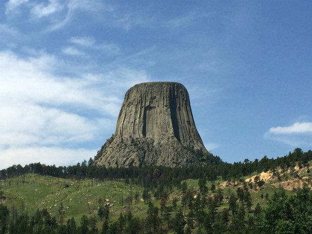
The first declared United States National Monument, Devils Tower was established in 1906 by President Theodore Roosevelt. The monument got its name in 1875 during an expedition led by Col. Richard Irving Dodge when his interpreter misinterpreted the name to mean Bad God’s Tower, which then became Devil’s Tower.
Gibson Steps (The Twelve Apostles) – Great Ocean Road, Australia
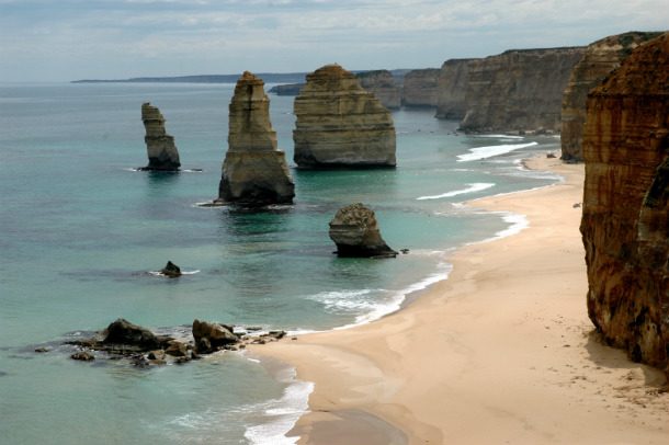
The Twelve Apostles is a collection of limestone stacks off the shore of Port Campbell National Park, near Great Ocean Road in Victoria, Australia. They were formed by the harsh weather conditions from the Southern Ocean gradually eroding the soft limestone to form caves in the cliffs, which then became arches, which in turn collapsed, leaving rock stacks up to 45 meters high.
Cave of the Crystals – Naica, Mexico
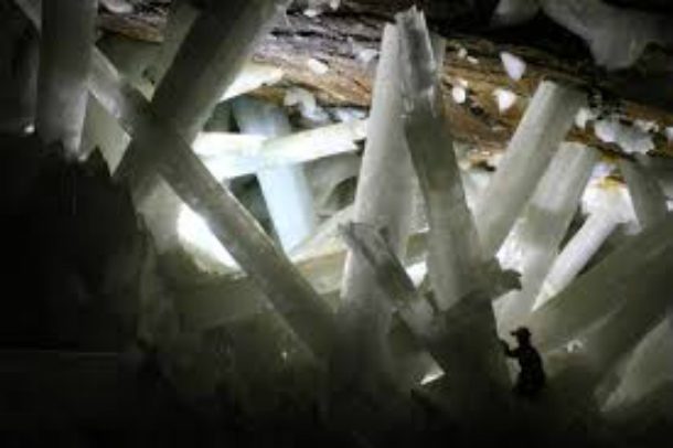
The Cave of the Crystals, or Giant Crystal Cave, is connected to the Naica Mine, 300 meters below the surface in Naica, Chihuahua, Mexico. The main chamber contains giant selenite crystals, some of the largest natural crystals ever found.
Door to Hell – Turkmenistan
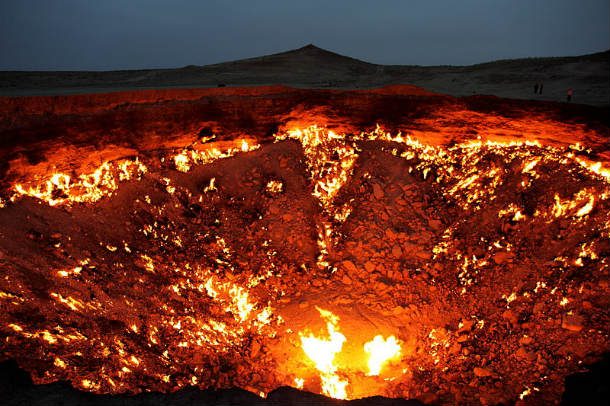
The Door to Hell is a natural gas field in Derweze, Turkmenistan. It’s known for its natural gas fire, which has been burning continuously since it was lit by Soviet petrochemical scientists in 1971. Fed by the rich natural gas deposits in the area, the pungent smell of burning sulfur pervades the area for some distance.
Chocolate Hills – Philippines
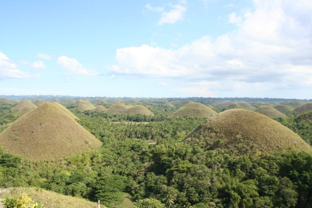
The Chocolate Hills is a geological formation in Bohol Province in the Philippines. There are at least 1,260 hills spread over an area of more than 50 square kilometers. They are covered in green grass that turns brown (like chocolate) during the dry season, hence the name.
Salar de Uyuni – Bolivia
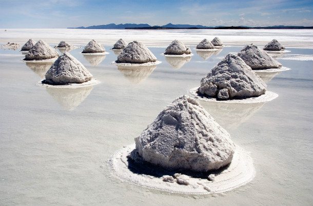
Salar de Uyuni is the world’s largest salt flat at 10,582 square kilometers. It’s located in southwest Bolivia, near the crest of the Andes and is at an elevation of 3,656 meters above sea level. The Salar was formed as a result of transformations between several prehistoric lakes. Currently, it holds 50% to 70% of the world’s lithium reserves.
Stone Forest – China
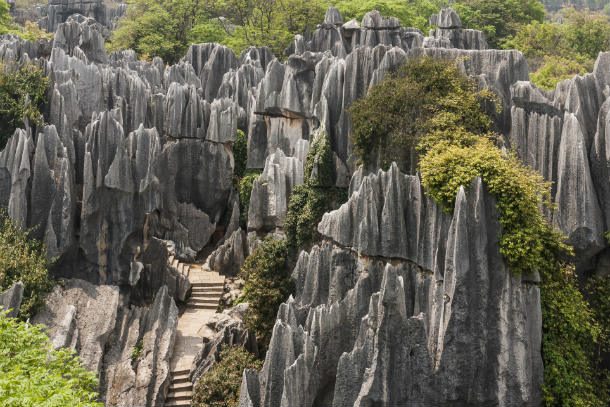
The Stone Forest is a notable set of limestone formations located in the Yunnan Province of China. The tall rocks seem to emanate from the ground resembling stalagmites, with many looking like petrified trees, creating the illusion of a forest made of stone.
Socotra Island – Yemen
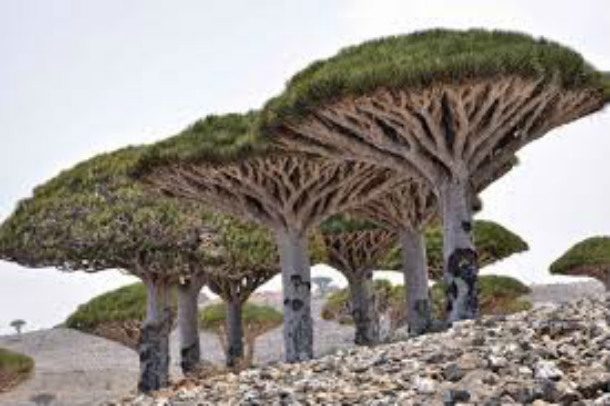
Lying some 240 kilometers east of the Horn of Africa and 380 kilometers south of the Arabian Peninsula, Socotra Island is a very isolated area. Through the process of speciation, a third of its plant life is not found anywhere else on the planet. It has been described as the most alien-looking place on Earth.
Fairy Chimneys – Turkey
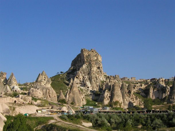
A hoodoo, also known as a fairy chimney, is a tall, thin spire of rock that protrudes from the bottom of an arid drainage basin or badland. Hoodoos, which can range from 5-150 feet tall are famously found in the historical Cappadocia region of Turkey.
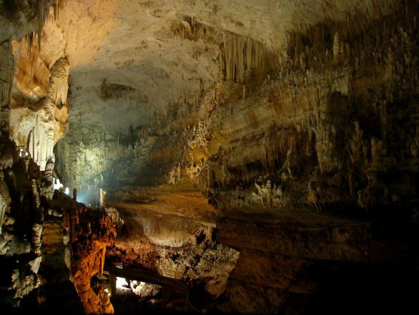
The Jeita Grotto – Lebanon
Skaftafell – Iceland
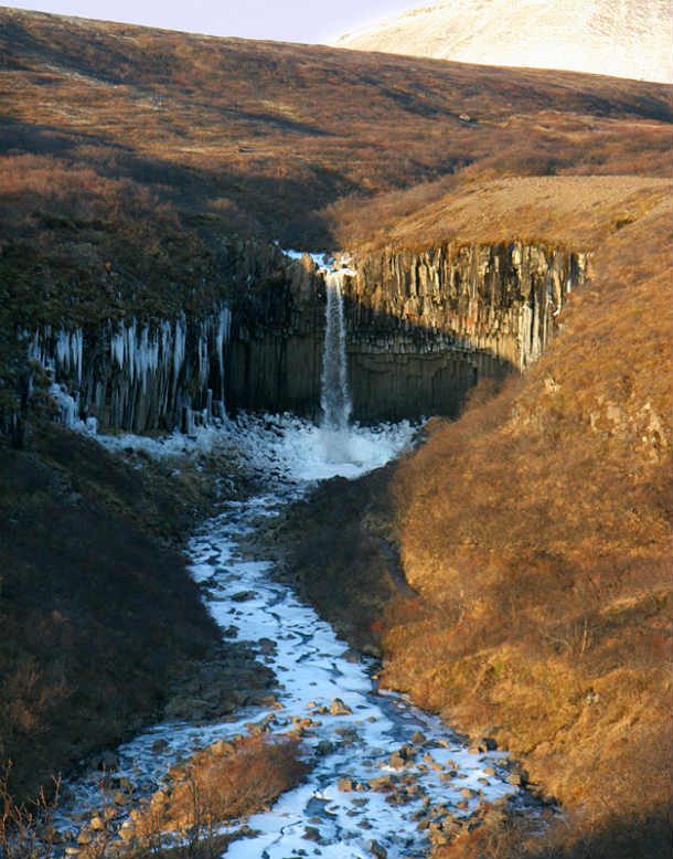
Skaftafell is a preservation area in southeast Iceland. The landscape is very similar to some of the Alps, but it has been formed over thousands of years by a combination of volcanoes and glaciers. It’s known for its agreeable climate and diverse geography.
Puerto Princesa Underground River – Philippines
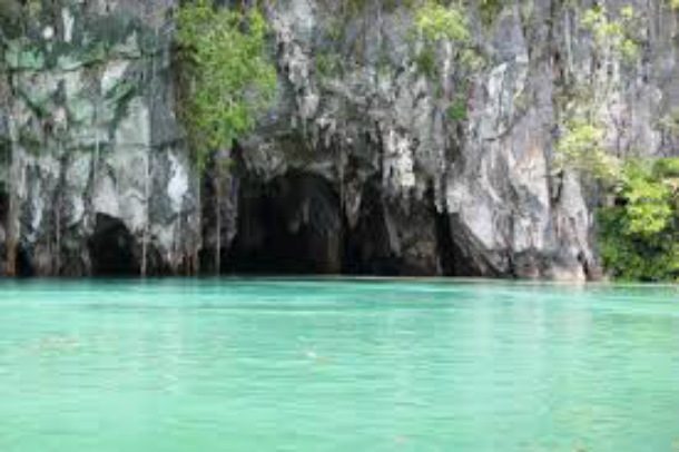
Located about 50 kilometers north of the city center of Puerto Princesa in the Philippines, this river is filled with complex rock formations, strange marine life, and massive caves. Deeper areas of the underground river are almost impossible for visitors to explore due to a lack of oxygen.
Yellowstone – Wyoming
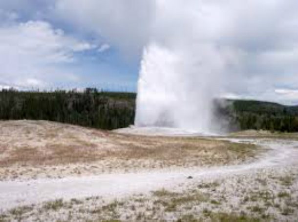
Surrounded by canyons, rivers, lakes, and mountain ranges, the Yellowstone Caldera is home to the largest super volcano on the continent. Grizzlies, free-ranging herds of bison, elk, and wolves are some of its many inhabitants. Possibly its most notable feature is Old Faithful, known as the most predictable geographical feature on Earth, as it erupts almost exactly every 91 minutes.
Arches National Park – Utah
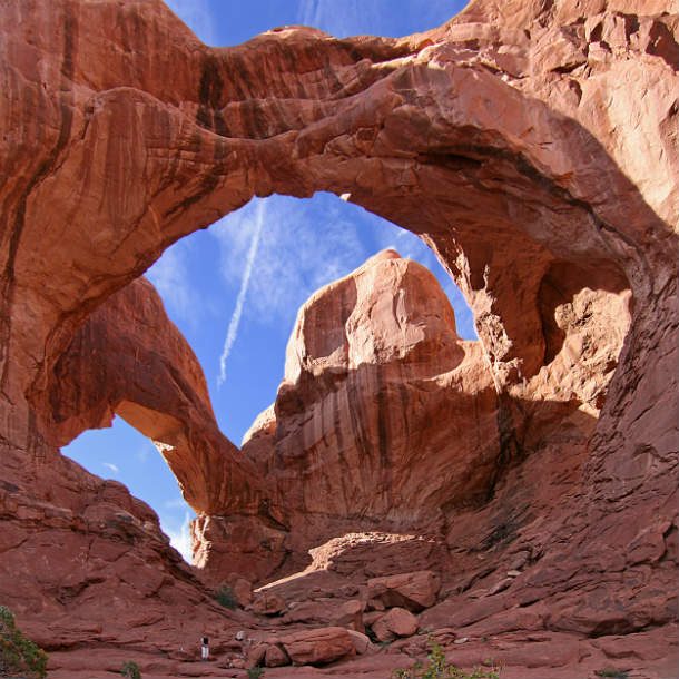
Arches National Park is a U.S. National Park in eastern Utah. It’s known for preserving over 2,000 natural sandstone arches, including the world-famous Delicate Arch, in addition to a variety of unique geological resources and formations. Forty-three arches have collapsed due to erosion since 1970.
Richat Structure – Mauritania
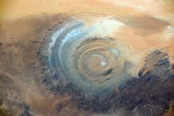
Also known as the Eye of the Sahara, this hypnotizing formation can be found in the desert of western Mauritania. Dutch Astronaut Andre Kuipers took this photo from the International Space Station. Although no one is exactly sure of its origin, it was initially interpreted as an asteroid impact structure because of its high degree of circularity. Today, however, it is speculated to be a highly symmetrical and deeply eroded geologic dome.
World of Ice Giants – Austria
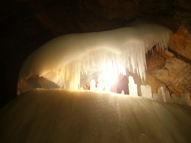
The Eisriesenwelt is a natural limestone ice cave located in Werfen, Austria, about 40 km south of Salzburg. It’s the largest ice cave in the world, extending more than 42 km and is visited by about 200,000 tourists each year.
Babele – Romania
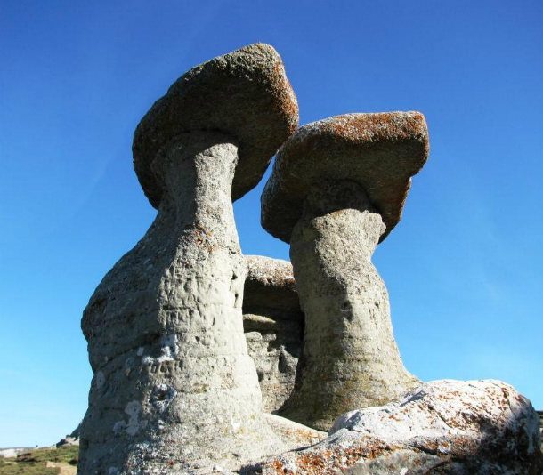
Babele, meaning “old women,” is the name of an area on the Bucegi Mountains plateau in Romania. One of the most popular tourist destinations in the country, its name comes from various mushroom-shaped rock formations scattered across the landscape.
The Wave – Arizona
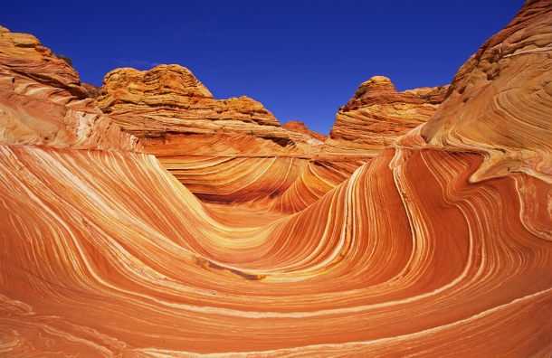
The Wave is a sandstone rock formation located near the Arizona-Utah border on the Colorado Plateau. It’s famous among hikers and photographers for its colorful, undulating forms and the rugged hike required to reach it.
Pancake Rocks and Blowholes – New Zealand
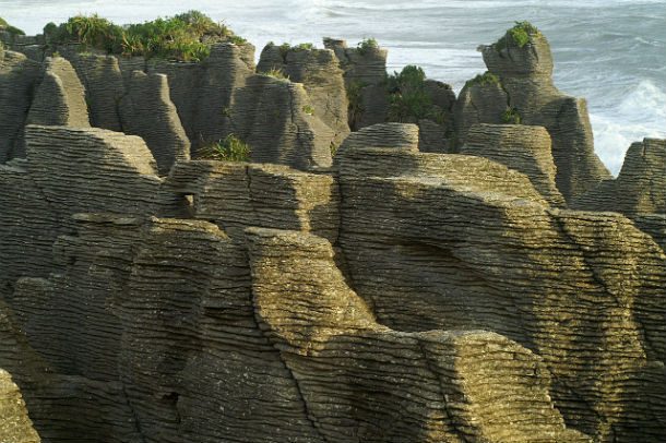
The Pancake Rocks are a heavily eroded limestone area where the sea bursts through several vertical blowholes during high tides. They are presently accessible by a number of walkways winding through the rock formations.
Fingal’s Cave – Scotland
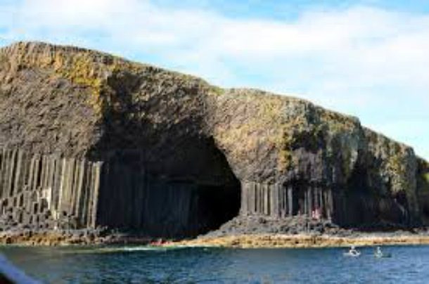
Fingal’s Cave is a sea cave on the uninhabited island of Staffa in Scotland. Its size, naturally arched roof, and eerie sounds produced by wave echoes, give it the atmosphere of a natural cathedral. The cave’s Gaelic name, An Uaimh Bhinn, means “the melodious cave.”

 2")

 4")


 8")


_in_Skaftafell,_November.jpg)
.jpg)
.JPG)